West Kameng District Arunachal Pradesh: History, Geography, Economy, Tourism, Administration, FAQs
West Kameng district is one of the most scenic and strategically important districts in Arunachal Pradesh. It lies in the western part of the state and shares borders with Bhutan and the Tawang district. Moreover, West Kameng is widely known for its mountainous terrain, cultural diversity, and natural beauty. As a result, it attracts travelers, researchers, and nature lovers alike. Although the district remains largely rural and remote, it continues to develop steadily through infrastructure and government initiatives. Consequently, West Kameng stands out as a region rich in tradition, biodiversity, and tourism potential.
West Kameng District Quick Overview
| Particulars | Details |
| District Name | West Kameng |
| State | Arunachal Pradesh |
| Headquarters | Bomdila |
| Region | Western Arunachal |
| Known For | Mountains, culture, tourism |
| Official Language | English |
| Major River | Kameng |
| Economy | Agriculture, tourism |
Historical Background of West Kameng District
West Kameng district has a rich historical background rooted in tribal traditions. Earlier, various indigenous communities such as the Monpa, Sherdukpen, and Aka inhabited the region. Therefore, the district developed a unique cultural identity.
Historically, the region maintained close ties with Tibet and Bhutan due to trade and cultural exchanges. Later, it came under Indian administration after independence. Consequently, West Kameng evolved into a modern district while preserving its heritage.
Moreover, its strategic location near international borders adds to its historical importance.
Geography and Location:
West Kameng district lies in the Himalayan region. It features rugged mountains, valleys, and rivers.
Key Geographic Features:
- Located in the Eastern Himalayas, the
- Kameng River flows through the district
- High-altitude terrain with forests
- Cold climate with heavy rainfall
Because of its geography, the district supports diverse ecosystems. Moreover, its natural landscapes enhance tourism potential. Therefore, West Kameng holds ecological significance.
Administrative Structure
West Kameng district follows a structured administrative system.
Administrative Highlights: The
- Deputy Commissioner oversees governance
- Divided into subdivisions and circles
- Local administrative bodies manage rural areas
Consequently, governance ensures the effective delivery of public services and development programs.
Economy of West Kameng District
The economy of West Kameng mainly depends on agriculture and tourism. However, handicrafts and trade also contribute.
Major Economic Activities:
- Agriculture
- Horticulture
- Tourism
- Handicrafts
Because of its terrain, terrace farming is common. Moreover, tourism generates income. Therefore, the district maintains a balanced rural economy.
Agriculture and Horticulture
Agriculture plays an important role in West Kameng.
Key Crops:
- Maize
- Millet
- Rice
- Fruits such as apples and oranges
Additionally, a favorable climate supports horticulture. Consequently, farmers benefit from diversified agriculture.
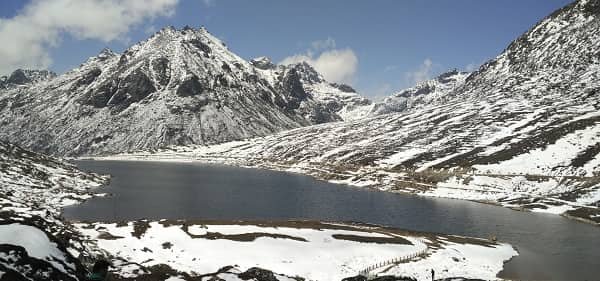
Tourism in West Kameng District
West Kameng offers several natural and cultural attractions. Therefore, it attracts tourists seeking adventure and peace.
Major Tourist Attractions:
- Bomdila: Scenic hill town
- Dirang Valley: Known for hot springs and landscapes
- Sessa Orchid Sanctuary: Rich biodiversity
- Eaglenest Wildlife Sanctuary: Famous for birdwatching
Because of these attractions, tourism contributes to the district’s economy. Moreover, eco-tourism continues to grow.
Connectivity and Transport
West Kameng district has improved connectivity.
Transport Options:
- Road: Connected via highways from Assam
- Rail: Nearest railway station in Tezpur
- Air: Nearest airport is Tezpur Airport
Because of these options, travel remains challenging but manageable. Consequently, connectivity is gradually improving.
Education and Infrastructure
West Kameng has improved its infrastructure over time.
Facilities Include:
- Schools and colleges
- Healthcare centers
- Banking services
- Road networks
Moreover, government initiatives aim to enhance infrastructure. Therefore, the district shows steady progress.
Culture and Lifestyle
West Kameng reflects a rich tribal culture and traditions. Therefore, diversity plays an important role.
Cultural Highlights:
- English is the official language, but local languages are widely spoken
- Festivals like Losar are celebrated
- Traditional attire and customs
- Community-based lifestyle
Consequently, the district maintains a vibrant cultural identity.
Challenges Faced by West Kameng District
Despite development, West Kameng faces several challenges.
Key Challenges:
- Remote location
- Limited infrastructure
- Harsh weather conditions
- Connectivity issues
However, government initiatives aim to address these issues. Therefore, development continues steadily.
Future Development Prospects
West Kameng has strong growth potential. Therefore, future development may focus on:
- Promoting eco-tourism
- Improving connectivity
- Enhancing infrastructure
- Supporting local communities
Consequently, the district may achieve sustainable development.
Final Words
West Kameng district combines natural beauty, cultural richness, and strategic importance. It plays a vital role in Arunachal Pradesh’s development. Moreover, its landscapes and traditions make it unique. Therefore, West Kameng continues to grow while preserving its identity. With improved infrastructure and sustainable development, it holds strong potential for the future.
FAQs
Q: Where is the West Kameng district located?
A: It is located in western Arunachal Pradesh.
Q: What is West Kameng famous for?
A: It is known for mountains, culture, and tourism.
Q: Which river flows through West Kameng?
A: The Kameng River flows through the district.
Q: What crops are grown in West Kameng?
A: Maize, millet, rice, and fruits are commonly grown.
Q: Is West Kameng a tourist destination?
A: Yes, it offers scenic and cultural attractions.
Q: How can I reach West Kameng?
A: You can travel by road or via Tezpur airport.
Q: Which language is spoken in West Kameng?
A: English is the official language, along with local languages.
Q: What are the main economic activities?
A: Agriculture, tourism, horticulture, and handicrafts.

