Koraput District Odisha: History, Geography, Economy, Tourism, Administration
Koraput district is one of the most scenic and culturally rich districts in the state of Odisha. It lies in the southern part of the state and forms a key segment of the Eastern Ghats region. Moreover, Koraput is widely known for its tribal heritage, natural beauty, and agricultural diversity. As a result, it attracts travelers, researchers, and development planners alike. Although the district remains largely rural, it continues to grow steadily through infrastructure development and government initiatives. Consequently, Koraput stands out as a district that blends tradition, ecology, and emerging economic potential.
Koraput District Quick Overview
| Particulars | Details |
| District Name | Koraput |
| State | Odisha |
| Headquarters | Koraput |
| Region | Southern Odisha |
| Known For | Tribal culture, hills, agriculture |
| Official Language | Odia |
| Major Rivers | Kolab, Indravati |
| Economy | Agriculture, forest resources |
Historical Background of Koraput District
Koraput district has a deep historical background shaped by tribal communities and regional kingdoms. Earlier, indigenous tribes such as the Kondh, Bonda, and Paraja inhabited the region. Therefore, Koraput developed a unique cultural identity.
Historically, the region came under the influence of the Kalinga Kingdom. Consequently, it gained cultural and administrative importance.
During British rule, Koraput became part of administrative divisions that focused on resource management. After independence, it emerged as a separate district and continued to evolve. Therefore, Koraput today reflects a blend of tradition and modern governance.
Geography and Location
Koraput district lies in the Eastern Ghats and features hills, valleys, and forests.
Key Geographic Features:
- Located in southern Odisha
- Hilly terrain with plateaus
- Rivers such as Kolab and Indravati
- Moderate climate with good rainfall
Because of its geography, agriculture and forest-based livelihoods thrive. Moreover, biodiversity enhances ecological importance. Therefore, Koraput holds environmental significance.
Administrative Structure
Koraput district follows a structured administrative system.
Administrative Highlights:
- District Collector oversees governance
- Divided into subdivisions and blocks
- Municipal bodies manage urban areas
- Panchayats govern rural regions
Consequently, governance ensures effective delivery of public services and development programs.
Economy of Koraput District
The economy of Koraput mainly depends on agriculture and forest resources. However, small industries and tourism also contribute.
Major Economic Activities:
- Agriculture
- Forest produce collection
- Handicrafts
- Tourism
Because of fertile land and natural resources, rural livelihoods dominate the economy. Moreover, traditional practices remain significant. Therefore, Koraput maintains a stable rural economy.
Agriculture in Koraput
Agriculture forms the backbone of the district’s economy.
Key Crops:
- Paddy (rice)
- Millets
- Pulses
- Vegetables
Additionally, rainfall supports farming activities. Consequently, agriculture sustains a large population.
Tribal Culture and Livelihoods
Koraput is known for its vibrant tribal culture. Therefore, traditions and customs play an important role.
Cultural Highlights:
- Diverse tribal communities
- Traditional crafts and handlooms
- Festivals and rituals
- Community-based lifestyle
Because of this diversity, Koraput preserves its cultural heritage. Moreover, tribal practices influence local livelihoods.
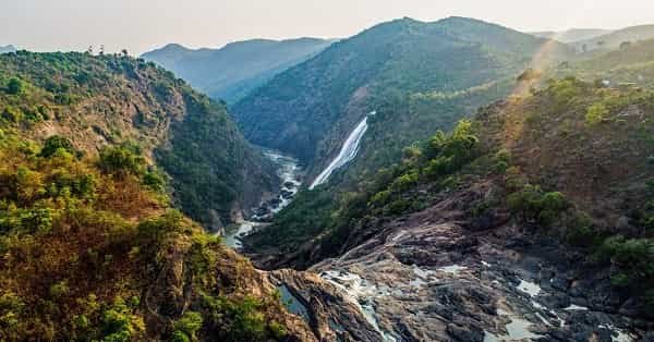
Tourism in Koraput District
Koraput offers several natural and cultural attractions. Therefore, it attracts tourists seeking peace and nature.
Major Tourist Attractions:
- Deomali Hills: Highest peak in Odisha
- Kolab Dam: Scenic reservoir
- Duduma Waterfalls: Majestic waterfall
- Gupteswar Cave Temple: Religious site
Because of these attractions, tourism contributes to the district’s economy. Moreover, eco-tourism continues to grow.
Connectivity and Transport
Koraput district has improving connectivity.
Transport Options:
- Road: Connected via highways
- Rail: Koraput railway station connects nearby regions
- Air: Nearest airport is Visakhapatnam Airport
Because of these options, travel remains manageable. Consequently, connectivity continues to improve.
Education and Infrastructure
Koraput has improved its infrastructure over time.
Facilities Include:
- Schools and colleges
- Healthcare centers
- Banking and financial services
- Road networks
Moreover, development initiatives continue to enhance infrastructure. Therefore, the district shows steady progress.
Challenges Faced by Koraput District
Despite development, Koraput faces several challenges.
Key Challenges:
- Limited industrial development
- Infrastructure gaps in remote areas
- Dependence on agriculture
- Accessibility issues
However, government initiatives aim to address these issues. Therefore, development continues steadily.
Future Development Prospects
Koraput shows strong potential for growth. Therefore, future development may focus on:
- Promoting eco-tourism
- Improving infrastructure
- Supporting tribal welfare
- Encouraging sustainable agriculture
Consequently, the district may achieve balanced development.
Final Words
Koraput district combines natural beauty, tribal heritage, and economic potential. It plays a vital role in Odisha’s cultural and ecological landscape. Moreover, its hills, forests, and traditions make it unique. Therefore, Koraput continues to grow while preserving its identity. With improved infrastructure and sustainable development, it holds strong potential for the future.
FAQs
Q: Where is Koraput district located?
A: It is located in southern Odisha.
Q: What is Koraput famous for?
A: It is known for tribal culture, hills, and natural beauty.
Q: Which rivers flow through Koraput?
A: The Kolab and Indravati rivers flow through the district.
Q: What crops are grown in Koraput?
A: Paddy, millets, pulses, and vegetables are commonly grown.
Q: Is Koraput a tourist destination?
A: Yes, it offers natural and cultural attractions.
Q: How can I reach Koraput?
A: You can travel by road, rail, or via Visakhapatnam airport.
Q: Which language is spoken in Koraput?
A: Odia is the primary language.
Q: What are the main economic activities?
A: Agriculture, forest produce, handicrafts, and tourism.

